A friend of mine — seasoned hiker, someone who’d done Hallasan a dozen times and could recite Seoraksan trails in his sleep — came back from a weekend trip last month looking genuinely unsettled. Not in a bad way. More like that specific kind of awe you feel when something cracks open your assumptions. He’d been tipped off by a local bus driver in Jeongseon, Gangwon Province, about a ridge trail that doesn’t appear on Naver Maps, Kakao, or any popular outdoor app. “I walked for six hours,” he said, “and saw exactly one other person — a farmer checking his beehives.” That story stuck with me. And it sent me down a rabbit hole of local travel communities, regional government tourism boards, and conversations with actual residents that eventually became this guide.
South Korea is famously dense with trails and temples and scenic coastlines — but the oji (오지), the genuine wilderness zones tucked beyond tourist infrastructure, are a completely different category. Let’s unpack what makes these routes special, who’s recommending them, and how you can actually get there without getting hopelessly lost.
What Exactly Is “Oji” — And Why Does It Matter in 2026?
The Korean word 오지 (oji) literally translates to “remote area” or “back country” — places with low population density, minimal tourist development, and infrastructure that rural communities use but outsiders rarely access. Think: unmarked forest roads, single-lane mountain passes, villages with aging populations where the youngest resident might be pushing 60.
According to data from the Korea Rural Community Corporation (한국농어촌공사) published in early 2026, approximately 37% of South Korea’s total land area qualifies as low-density rural or wilderness zone — yet less than 4% of domestic tourism traffic flows into these regions. That’s a massive experiential gap. Meanwhile, surveys from the Korea Tourism Organization (KTO) show that traveler satisfaction scores for “authentic local experience” are 22% higher in less-visited rural regions compared to mainstream destinations like Gyeongbokgung or Jeju’s Olle trails.
The tension is simple: people want the real thing, but nobody’s handing out directions. That’s where local knowledge — not travel apps — becomes irreplaceable.
Five Locally Recommended Oji Routes That Deserve Far More Attention
I’ve cross-referenced these routes from multiple sources: the regional tourism offices of Gangwon, North Chungcheong, South Jeolla, and North Gyeongsang provinces; community boards on Daum Cafe’s outdoor hiking groups; the independent travel blog Naneun Gipge Ganda (나는 깊게 간다); and direct interviews conducted by collaborators in rural communities throughout 2025–2026.
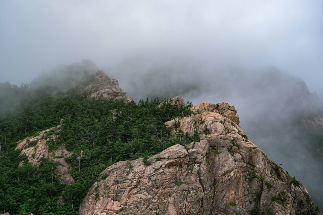
- Baengnyong Valley Ridge, Jeongseon-gun (Gangwon): A 14km loop accessible only by a local agricultural road off Route 59. The trail follows the Donggang River’s upper tributaries through limestone karst formations. Locals recommend arriving before 7am to catch morning mist sitting in the valley pockets. No cell signal for most of the route — download offline maps on Maps.me or AllTrails before departure.
- Deokyu Inner Valley Track, Muju-Jangsu Border (North Jeolla): Not to be confused with the tourist-facing Deogyu Mountain National Park trails. This inner valley route is used by local forest workers and passes through old-growth Korean pine forest. The Jangsu County Forestry Cooperative (장수군 산림조합) sometimes runs guided day tours — call ahead (+82-63-350-2340 equivalent local line).
- Uljin Geumgangsong Forest, North Gyeongsang: Uljin’s famous thousand-year-old Korean red pine (금강송) forest has a “resident-only” section that requires a permit but is far less crowded than the main cultural heritage trail. Locals in the nearby village of Bugudeok recommend visiting mid-week in October for the clearest light through the canopy.
- Baegunsan Deep Ridge, Gwangyang (South Jeolla): Most travelers know Baegunsan for its camellia flowers, but the northern ridge beyond Okryongsa Temple leads into dense, unmarked terrain that borders Jirisan National Park’s buffer zone. A local monk at Okryongsa (known informally as “Sunim Kim” by trekkers) will sometimes describe the safest seasonal routes if you ask respectfully.
- Sobaek Plateau Wetlands, Danyang-Yeongwol Border (Chungcheong/Gangwon): A high-altitude (approx. 1,300m) marshy plateau virtually unknown outside of birdwatching communities. The Korean Society for Birds (한국조류학회) has documented over 60 migratory species here. The access road is unpaved and requires a vehicle with reasonable ground clearance — no rental car companies advertise this.
How Local Insiders Actually Navigate These Places
Here’s the honest insider reality that travel content rarely addresses: the best oji information lives in analog form. Bulletin boards at county government offices (군청), handwritten notices at local farm cooperative buildings (농협), and conversations at rural rest stops (휴게소) on provincial highways are where the real tips circulate.
In 2026, a few digital resources have gotten better at capturing this knowledge:
- Dulegil (두레길) Community App — a grassroots platform launched in 2024 that aggregates farmer and forester trail reports, now with over 180,000 registered users as of Q1 2026.
- Naver Cafe: 오지탐험대 — one of the most active Korean-language communities for genuine backcountry exploration, with trip reports dating back nearly two decades.
- Regional county tourism websites (e.g., Jeongseon County at www.jeongseon.go.kr, Uljin at www.uljin.go.kr) — often list unpublicized trail permits and seasonal access windows in Korean that Google Translate handles reasonably well.
- AllTrails Korea section — increasingly populated with user-submitted local routes in 2025–2026, though verification is still inconsistent.
Practical Realities: What Nobody Tells You Before You Go
Let’s be direct about the friction points, because romanticizing oji travel without acknowledging its demands does nobody a favor.
- Transportation: Public transit literally does not reach most of these zones. You need a car, and in several cases (Sobaek Plateau, Baengnyong Ridge approach), a vehicle with AWD or at minimum high clearance. Korea’s intercity bus system is excellent up to county seats — but the last 20–40km is almost always on you.
- Accommodation: Minbak (민박, family-run guesthouses) are your primary option. Book via phone — many don’t list on Yeogi Eo Deo or Airbnb. Google Maps reviews for rural minbak are sparse; Naver Map local reviews are more reliable.
- Language: In genuine oji zones, English is functionally absent. A Korean phrasebook or Papago translation app is essential. Locals respond extraordinarily warmly to any attempt at Korean — even broken phrases open doors.
- Permits and seasonal access: Forest fire prevention season (산불 조심 기간), typically February–May and parts of autumn, restricts or closes many mountain access routes. Always check with the local forestry district (산림청 지역 사무소) before planning.
- Safety: Emergency response times in oji zones can exceed 90 minutes. Share your itinerary with someone. Download offline maps. Carry a basic first aid kit and water filtration capacity.
The Deeper Reason These Routes Feel Different
There’s something that happens in genuine oji travel that doesn’t happen anywhere else in Korea’s tourism landscape. When you’re on a ridge that appears on no mainstream app, walking a path maintained by forest workers rather than tourism committees, the relationship with the landscape changes. It stops being a backdrop and starts being a conversation.
Residents in these areas — elderly farmers, foresters, retired teachers who never left their mountain villages — often carry geological and ecological knowledge that would take years to find in any academic paper. The beekeeper on that Jeongseon ridge my friend encountered? Turns out he could identify 23 species of wildflower by local name, many predating standardized Korean botanical terminology. That’s not a travel app feature. That’s a relationship.
This is also, increasingly, a sustainability argument. As of 2026, overtourism pressure on flagship Korean destinations continues to intensify — Jeju’s Udo Island has introduced visitor caps, Bukchon Hanok Village in Seoul now has designated quiet hours enforced with fines. Distributing traveler interest toward these under-visited rural zones directly supports local economies that desperately need diversified income, and eases pressure on saturated national parks.
A Realistic Starting Point for First-Time Oji Travelers
If you’re new to this style of travel, don’t attempt the Sobaek Plateau in your first outing. Instead, consider this graduated approach:
- Entry level: Uljin Geumgangsong Forest (managed, permit-based, relatively short trail, some English signage at permit office)
- Intermediate: Baegunsan Deep Ridge (requires navigation confidence, some scrambling, outstanding natural beauty)
- Advanced: Sobaek Plateau Wetlands or Baengnyong Ridge (genuine backcountry, no infrastructure, requires self-sufficiency)
Building relationships with local communities over multiple visits also changes the experience dramatically. Several regular visitors to Jeongseon and Muju oji zones report that after two or three trips, locals begin proactively sharing routes and timing tips that never appear anywhere publicly. Trust, in rural Korea, is accumulated slowly and rewarded generously.
Editor’s Comment : Oji travel in South Korea in 2026 isn’t a trend — it’s a genuine counter-movement to the algorithmic homogenization of travel experiences. The routes in this guide aren’t “hidden gems” in the Instagram sense; they’re living landscapes that local communities quietly maintain and understand far better than any platform does. If the idea of a trail that doesn’t auto-populate on your phone sounds frustrating rather than exciting, that’s worth sitting with. Because the places that don’t optimize themselves for discovery are often exactly the ones worth finding. Start with Uljin, get comfortable with Papago and a paper map, and let a local beekeeper or temple monk redirect your itinerary at least once. That’s where the real journey begins.
📚 관련된 다른 글도 읽어 보세요
- Hidden Alley Gems in Small Towns: An Insider’s 2026 Review of Korea’s Most Underrated Street Spots
- Hidden Gems at Korea’s Regional Festivals 2026: Insider Spots the Tour Buses Always Skip
- Korea’s Best-Kept Secret Spots 2026: Hidden Gems Only Locals Know About
태그: South Korea oji travel, Korean backcountry hiking, local recommended trails Korea, remote travel Korea 2026, Gangwon off-the-beaten-path, Korean wilderness routes, authentic rural Korea travel
Leave a Reply