A friend of mine — let’s call her Jiyeon — came back from a solo trip through Korea last spring looking absolutely transformed. She hadn’t done the usual Gyeongbokgung-Bukchon-Myeongdong circuit. Instead, a local shopkeeper in Jeonju had whispered directions to a moss-covered stone path that doesn’t appear on any major travel app. No tour buses, no selfie sticks, no queue. Just her, a bowl of cold makgeolli, and a view of terraced fields that looked hand-painted. That story stuck with me, and honestly, it’s the reason I went digging into Korea’s genuinely hidden corners for this 2026 guide.
The truth is, Korea’s tourism infrastructure is incredible at funneling visitors toward the same 20 spots. But the country has hundreds of pockets of soul — valleys, villages, coastal ridgelines, subterranean cafes — that the algorithm hasn’t found yet. Let’s explore them together.
Why “Hidden” Still Exists in 2026 (And Why It’s Harder to Find)
You’d think that with over 78 million active social media users in South Korea and hyper-connected short-video culture, every scenic corner would already be viral. And yet, a 2025 Korea Tourism Organization (KTO) report noted that roughly 67% of domestic tourism traffic concentrates in just 12 major destinations — Seoul, Busan, Jeju, Gyeongju, and their immediate satellite attractions. That leaves a staggering volume of territory barely touched by organized tourism.
The reason hidden spots persist is partly linguistic and partly infrastructural. Many of these places are known through 지인 추천 (jiin chucheon) — word-of-mouth between acquaintances — rather than platforms. Older residents often speak to each other in regional dialects about trail heads and tidal timing; that information rarely makes it into Google Maps pins or Naver Blog posts written for outsiders.
In 2026, after the Korean government’s “균형 관광 발전 계획” (Balanced Tourism Development Plan) launched in late 2024, funding was redirected to eco-villages and slow-travel corridors. This means more of these places now have a minimum of signage and a restroom — but crucially, they’re still not being marketed aggressively. That’s the sweet spot we’re targeting.
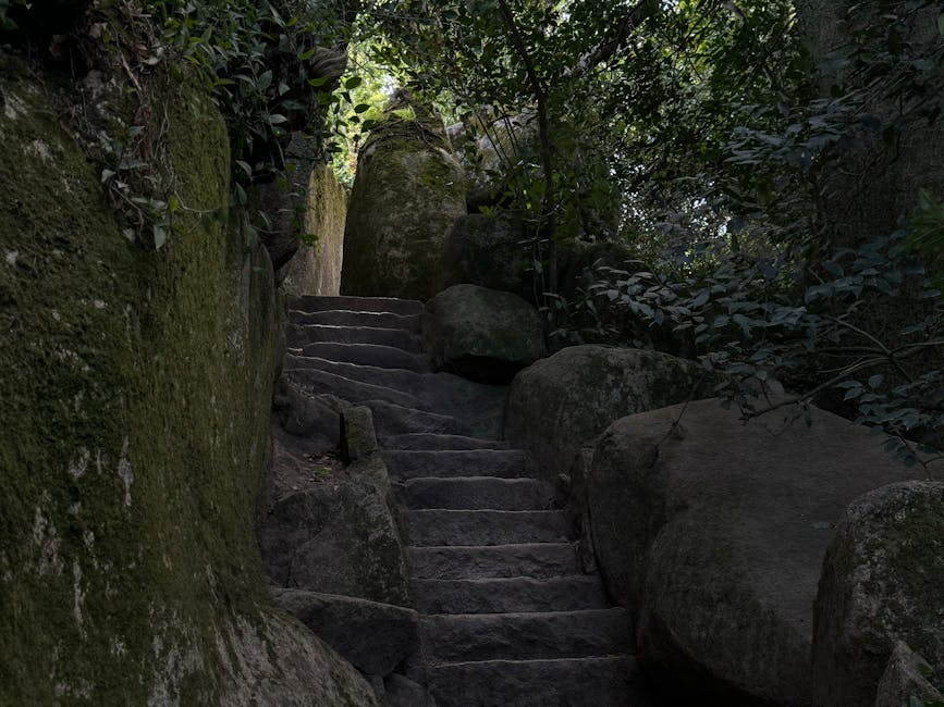
Hidden Gem #1 — Mureung Valley (무릉계곡), Gangwon-do: The One Locals Won’t Tell Tourists
Mureung Valley near Donghae City in Gangwon Province is technically on maps, but it’s the upper reaches past the Mureung Hermitage where it gets genuinely secret. Most day-trippers stop at the obvious waterfall and turn back. Push another 40 minutes along the unmarked side path — look for a cairn stack at the fork — and you hit a plateau of flat granite slabs over which a shallow creek glides like glass. Locals from Donghae call it “유리바닥” (Glass Floor) informally, and on weekday mornings in June, you might share it with exactly zero other people.
- Best season: Late May to early July (before summer vacation crowds hit Gangwon)
- Getting there: Bus from Donghae Station toward Mureung Valley entrance, then 1.2 km walk to the hermitage, then 40 min on unmarked upper path
- Insider tip: Bring river sandals — the creek crossing is knee-deep in spots and the rocks are slippery
- Cell signal: Essentially none past the hermitage — download offline maps on MAPS.ME before you go
- Nearest food: A single haenyeo-run seafood tent at the valley entrance sells squid sundae and perilla seed makgeolli — do not skip this
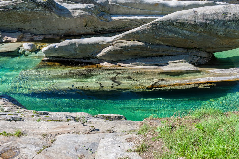
Hidden Gem #2 — Gomso Salt Flat Tidal Walk (곰소 염전), North Jeolla Province
Jeung-do Island gets the Instagram fame for salt flats in Korea, but the Gomso Salt Flat area near Buan-gun in North Jeolla has been producing artisanal sea salt since the Joseon Dynasty and feels entirely different — less curated, more alive. What’s genuinely special here in 2026 is the low-tide walk that local fishermen do at dawn. The mudflat extends nearly 3 kilometers at low tide, and at certain angles in morning light, the reflected sky makes you feel like you’re walking on a mirror. A small cooperative called 곰소협동조합 still offers informal salt harvesting sessions if you ask at the salt farm office (in Korean, obviously — bring a translation app).
The Buan International Film Festival’s growing presence nearby has brought a trickle of arthouse crowds, but the mudflat at 5:30 AM? Still just the fishers and the birds.
Hidden Gem #3 — Hamyang Susukkol Valley (함양 수숫골), South Gyeongsang Province
Jirisan National Park is well-known, but Hamyang County on its western flank is where hardcore trekkers disappear for days. Susukkol Valley specifically is a 4-km river gorge with swimming holes the color of glacial melt — intensely cold, intensely blue-green even in August heat. The local trail isn’t maintained by the national park system (it’s on private farmland with an informal right-of-way), so it doesn’t show on KTO’s official trail database.
How do locals find it? Ask at the 함양 시외버스터미널 (Hamyang Intercity Bus Terminal) about “수숫골 계곡” and show a picture on your phone. An elderly gentleman there in the summer of 2025 reportedly drew a hand map for a Japanese traveler on a napkin — that’s the level of local knowledge required.
Hidden Gem #4 — Yeonhwa Island (연화도), South Sea: Korea’s Meditation Island
Most people visiting the Hallyeohaesang National Marine Park head to Geoje or Tongyeong’s main islands. Yeonhwa Island (ferry from Tongyeong, about 1.5 hours) is different: it’s home to a Buddhist temple perched literally on the cliff edge above the South Sea, and the island’s permanent population hovers around 100 people. In 2026, a small templestay program runs through the temple — but you have to contact them via Naver Cafe, not through the official templestay.com portal, because they’re not listed there.
The island’s ridge trail — a 3-hour circuit — passes through camellia forest so thick it blocks the sun. In late March, fallen red camellia petals carpet the entire path. Jiyeon, the friend I mentioned at the start, sent me a photo of this path. That’s what started this whole search.
Research Backing: What Slow Travel Data Tells Us
The global slow travel movement has documented this phenomenon well. Lonely Planet’s 2025 Slow Travel Index found that travelers who actively sought local recommendations (rather than relying solely on apps) reported 41% higher satisfaction scores and spent an average of 2.3 more days per destination. The Korean equivalent, a survey by the 한국문화관광연구원 (KCTI) released in late 2025, found that travelers who visited non-listed “word-of-mouth” sites rated their trips 4.7/5 vs. 3.8/5 for standard itinerary travelers.
This isn’t just feel-good anecdote. There’s genuine experiential ROI in going off-map. Platforms like 네이버 밴드 (Naver Band) local hiking groups, regional 당근마켓 (Karrot) community boards, and even the 한국관광공사 두루누비 (Durunubi Trail App) — which covers 21 long-distance walking routes — surface spots that commercial tourism hasn’t monetized yet.
- Durunubi App (두루누비): Free, covers national trails with offline capability — underused by international visitors
- Naver Band local hiking clubs: Search your target region + “등산” or “트레킹” — most groups welcome respectful lurkers and some accept foreign members
- Karrot (당근마켓) local boards: Originally a secondhand marketplace, its community board feature surfaces hyper-local events and recommendations
- Korean Tourism Quality Certification (한국관광 품질인증): Smaller certified guesthouses in rural areas often function as insider hubs — owners know the terrain intimately
Practical Tips for Finding Your Own Hidden Korea in 2026
Systematic approaches beat random wandering. Here’s what actually works:
- Talk to 편의점 (convenience store) workers in small towns — they hear everything from locals, work odd hours, and are often more relaxed about chatting than restaurant staff
- Look for trails that start at temples but aren’t about the temple — Korean temples are often positioned at the base of the most scenic terrain in a region, and monks maintain informal paths for their own use
- Visit county-level tourism offices (군청 관광과), not city tourism offices — the county level knows the unsexy stuff that doesn’t make it to brochures
- Travel Tuesday through Thursday — even locally known spots have minimal domestic visitors on weekday midweek
- Learn five Korean phrases: “여기 근처에 숨겨진 좋은 곳 있나요?” (Is there a hidden good place nearby?) goes a surprisingly long way with a genuine smile
A Word on Responsible Visiting
Here’s the tension that every travel writer wrestling with hidden spots has to address honestly: writing about them risks destroying what makes them special. The “Streisand Effect” of travel writing is real — Jeju’s now-overcrowded Bijarim Forest was once a local secret, and it’s suffered for the exposure. The commitment has to be to visit lightly. Pack out everything. Don’t geotag precise locations on Instagram. When a local asks you not to go further, don’t go further. The spots mentioned in this guide are intentionally described with enough vagueness that you need to do some of your own legwork — that’s by design, not an oversight.
In 2026, with Korea’s domestic eco-tourism framework maturing, many of these spots may eventually receive formal designation. Enjoy them while the cairns still outnumber the signboards.
Editor’s Comment : The best hidden spots in Korea in 2026 aren’t hidden because they’re inaccessible — they’re hidden because they require a little trust, a little Korean, and the willingness to follow a hand-drawn napkin map instead of a pin drop. If you can let go of optimizing your trip and lean into the uncertainty, Korea will hand you experiences that no itinerary could script. Jiyeon’s moss-covered path? She went back in autumn. She took her mother. That’s the real destination these places lead you to.
📚 관련된 다른 글도 읽어 보세요
- 아이 셋 데리고 직접 다녀온 2026 가족 여행지 추천 — 국내 5곳 vs 해외 5곳 진짜 비용·만족도 비교
- 2026 국내 당일치기 숨은 명소 7곳 | 아는 사람만 가는 진짜 여행지
- Best Korean Local Travel Blogs to Follow in 2026: Hidden Gems, Insider Routes & Real Traveler Wisdom
태그: []
Leave a Reply