It started with a blurry photo my colleague sent me from his weekend trip. ‘Where is this?’ I typed back, half-convinced he’d accidentally screenshot a Norwegian fjord wallpaper. ‘Gyeongbuk coast,’ he replied. ‘Two hours from Daegu. You’ve never heard of it.’ And he was right — I hadn’t. That moment sent me down a rabbit hole of weekend drives, ferry rides, and gravel roads that dead-end at cliffs so dramatic they feel stolen from somewhere much more famous. After years of chasing Korea’s coastal edges, I want to share the spots that rarely show up on any travel app’s ‘Top 10’ list.
Why Korea’s Lesser-Known Coasts Are Having a Moment in 2026
Let’s talk numbers for a second, because they tell an interesting story. According to Korea Tourism Organization data from early 2026, domestic overnight travel bookings surged 34% compared to the same period three years ago, driven largely by a growing appetite for ‘slow travel’ and nature-immersive experiences. But here’s the twist — while Jeju Island and Busan’s Haeundae remain magnets for crowds, search trend analysis from Naver and Kakao Maps reveals a sharp uptick in queries for terms like ‘비밀 해변’ (secret beach) and ‘해안 절벽 트레일’ (coastal cliff trail), up roughly 58% year-on-year. Travelers are actively looking to escape the Instagram-famous spots. They want raw coastline, not boardwalks.
Korea’s eastern, southern, and western coastlines span over 17,000 km of total shoreline — a figure that surprises most people, including Koreans themselves. The sheer length means even well-traveled locals have only scratched the surface. The spots I’m going to walk you through sit in that vast, beautiful gap between ‘well known’ and ‘completely undiscovered.’
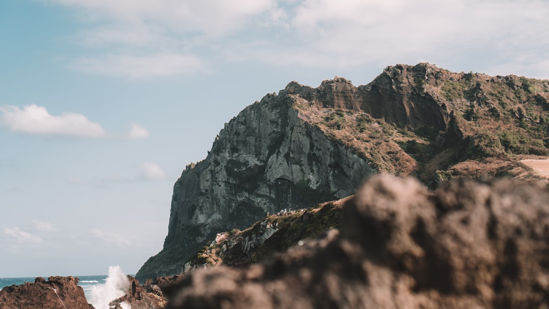
Guryongpo’s Hidden Rocky Bays: The Real East Coast Story
Most people driving the east coast stop at Pohang for crab and call it done. Push south another 30 minutes toward Guryongpo (구룡포), and you’ll hit a series of small rocky inlets that look like scaled-down versions of Ireland’s Wild Atlantic Way. The fishing village itself has been undergoing a quiet cultural revival — there’s a preserved Japanese colonial-era street that draws some visitors — but the real treasure is the coastal path that snakes south from the village harbor. After about 40 minutes on foot, you hit a completely open headland with basalt columns rising out of the water. Low tide is everything here; check the Korea Hydrographic and Oceanographic Agency’s tide prediction tool (khoa.go.kr) before you go. At low tide, you can walk out onto a tidal platform surrounded by the columns. High tide? They disappear. The timing matters enormously.
Gosapo Beach, Chungnam: The West Coast’s Best-Kept Secret
The west coast gets dismissed as ‘mudflat country’ by people who haven’t really explored it, and honestly, that reputation does its hidden gems a favor. Gosapo Beach (고사포해변) in Boryeong sits tucked inside a pine forest that comes right down to the shore. What makes it remarkable is the combination of a fine-sand beach, almost zero development, and a coastal ridge trail that gives you elevated views across Cheonsu Bay. The sunset light here in autumn and early winter is genuinely extraordinary — the shallow tidal gradient means the water catches the evening sky in a way that deeper-coast beaches simply don’t replicate. The nearest accommodation options are basic (think small minbak guesthouses), but that’s exactly why the beach at dawn feels like you rented it privately.
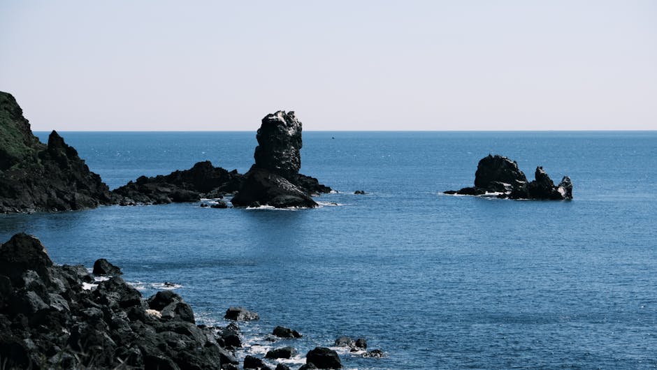
Sinjido Island, South Jeolla: A Ferry Ride Into Silence
Getting to Sinjido (신지도) from the mainland involves a bridge now, which has made it slightly more accessible — but ‘slightly’ is the operative word. The island’s southern shoreline, particularly around Myeongsasimni Beach, has long been considered one of Korea’s finest stretches of sand by the small community of coastal geographers and wild swimmers who pay attention to such things. What many visitors miss entirely is the cliff path on the island’s western edge. It requires a car and then a 20-minute hike on an unmarked trail, but the reward is a series of exposed sea stacks and a natural arch that frames the open ocean. South Sea light in summer is softer and more diffused than the east coast — completely different photographic mood.
Practical Breakdown: What You Actually Need to Know
- Best seasons: Late September through November for coastal clarity and lower humidity; early March for wild coastal vegetation without summer crowds.
- Tide awareness: For rocky tidal spots (especially Guryongpo), always check KHOA tide tables at least 48 hours ahead. The optimal window is usually 1–2 hours before low tide.
- Navigation: Kakao Maps outperforms Google Maps significantly for rural Korean roads. Many of these spots have only Korean-language marker names — screenshot the Korean characters before you leave cell range.
- Footwear: Basalt and granite coastal platforms are deceptively slippery. Trail shoes with rubber soles, not hiking boots with aggressive lugs, grip better on wet coastal rock.
- Accommodation: For Gosapo, check Yanolja or Goodchoice apps for last-minute minbak openings — advance booking isn’t always necessary outside of summer peak weeks.
- Drone rules: Korea’s coastal airspace regulations tightened further in late 2025. Check the MOLIT Drone One-Stop portal (drone.onestop.go.kr) for any restricted zone overlaps before flying near military coastal areas.
- Solo hiking safety: Register your trail plan with the National Park Service trail registration system if you’re going off any marked path — even for short unmarked coastal scrambles.
What International Slow Travel Platforms Are Saying
It’s worth noting that Korean coastal travel has started appearing in international niche travel media in 2026 in ways it simply didn’t before. Slow Travel News (slowtravelnews.com), a UK-based platform focused on low-impact travel, featured a piece in January 2026 specifically calling out Korea’s lesser-known coastlines as ‘criminally under-documented’ compared to Japan’s Izu Peninsula or Taiwan’s east coast highway. Elsewhere, the community at The Outbound Collective has seen a spike in Korean coastal route submissions — routes around Namhae Island and the Hallyeo Maritime National Park corridors in particular. This external validation matters because it suggests these places are genuinely remarkable by global standards, not just charming by domestic comparison.
How to Find More Spots Like These
Here’s my actual workflow for sourcing unknown coastal spots before a trip. I cross-reference three sources: Naver Blog posts tagged with ‘해안 절경’ or ‘숨겨진 해변’ from within the last six months (recent posts catch spots before they trend), the Korean Coastal Trail (해파랑길/남파랑길/서해랑길) official route maps which pass through dozens of undervisited points, and Google Earth’s satellite layer, which I use to look for natural features — arches, stacks, inlets — that exist near road access but don’t have any tourism marker. When all three sources align, you’ve almost certainly found something worth driving to.
Realistic Expectations and Alternatives
Not every hidden coastal spot delivers on the promise of a blurry photo. Some spots that look extraordinary on satellite imagery turn out to be on private fishing operation land, or accessible only by boat charter that requires group booking. If you hit a wall like that, don’t write off the area — ask locally at the nearest fishing port (수산시장 or 항구). Fishermen and harbor staff often know the most spectacular accessible spots within 10 km of where you’re standing, and they’ll usually share if you ask respectfully. The Hallyeo Maritime National Park also offers guided sea kayaking tours that access coastal arches and caves you simply can’t reach on foot — that’s a genuinely excellent alternative for spots with no land access.
Editor’s Comment : The best coastal experiences in Korea in 2026 aren’t the ones with parking lots and souvenir shops — they’re the ones where you have to work a little for the view. The gap between ‘well-known’ and ‘unknown’ on Korea’s coastline is enormous, and that gap is genuinely one of the more exciting travel frontiers available to someone willing to drive past the last convenience store, lace up proper shoes, and check a tide table. Start with one of the spots above and let the coastline pull you further. It always does.
📚 관련된 다른 글도 읽어 보세요
- Beyond the Tourist Trail: Hidden Gems of Gangwon, Gyeongsang & Jeolla Provinces in 2026
- 지도에 없는 드라이브 코스 7선: 현지인만 아는 국내 비밀 명소 2026 완전판
- 방학 때 해외여행 패키지 120만원 아꼈다: 2026 가족여행 비용 절약 완전 가이드
태그: []
Leave a Reply