It started with a tip from a friend who does weekend road trips obsessively — the kind of person who has a dedicated notebook for gas station ratings. He texted me last spring: “Dude, forget Nami Island. I found a coastal road in South Jeolla that made me pull over and just sit there for 20 minutes.” That text haunted me for weeks. So I did what any self-respecting road trip enthusiast would do — I packed the car, grabbed a thermos of instant coffee, and started hunting down Korea’s most under-the-radar drive routes.
What I found surprised me. Korea’s highway infrastructure has expanded dramatically over the past decade, but that growth has paradoxically hidden some of the most stunning routes behind the noise of tourist traffic. The secret spots are still there — they’re just not on the first page of Naver search results. Let me share what I found, and more importantly, what you won’t find in any travel brochure.
Why “Secret” Routes Exist — and Why They Stay Secret
Korea’s road network has grown to over 112,000 km of paved roads as of 2026, according to the Korea Road Corporation (한국도로공사). Yet tourism data from the Korea Tourism Organization shows that roughly 73% of domestic road trip visitors concentrate on just 12 major routes — things like the East Coast Highway (동해안 국도), the Gyeongbu Expressway corridor, or Jeju Island’s 1132 Circular Road.
That leaves an enormous amount of national road (국도) and local road (지방도) mileage largely undiscovered by casual travelers. The reasons routes stay secret are actually quite logical:
- No Instagram-able landmark at the end — many hidden routes reward the journey, not a specific destination
- Narrow road width — some are single-lane or 1.5-lane roads that navigation apps deprioritize
- No rest stops or cafes nearby — which filters out less adventurous drivers immediately
- Seasonal accessibility issues — some mountain passes close in winter or during heavy rain seasons
- Lack of English signage — international visitors rarely venture off major routes
Once you understand why these roads stay hidden, you can actually use that logic as a filter to find more of them yourself.
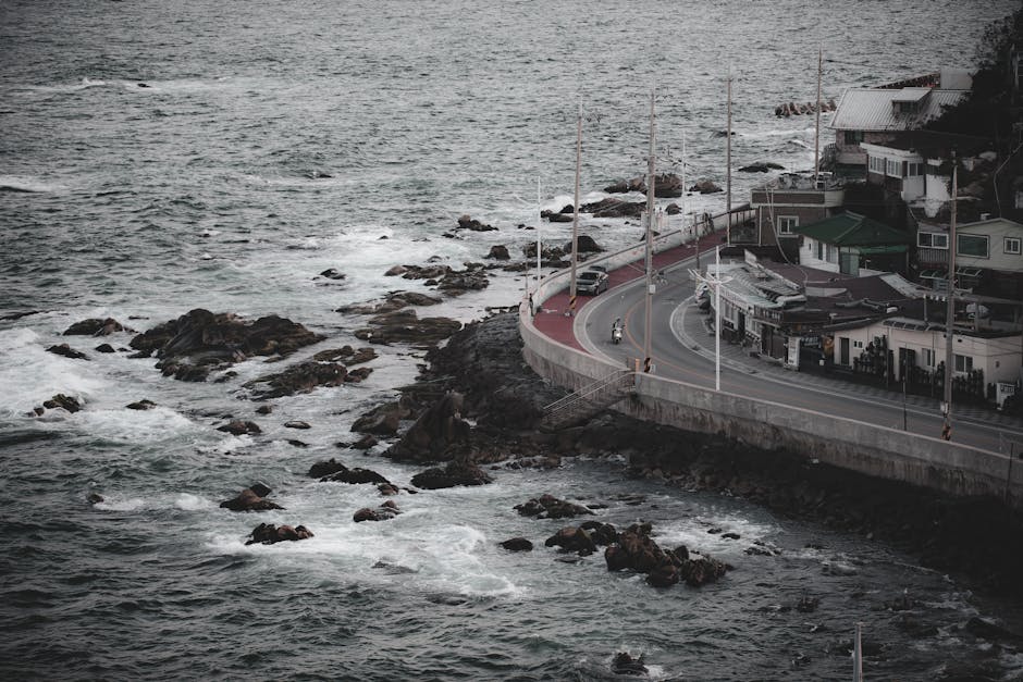
Route 1: Goheung Peninsula Loop (고흥반도 순환로) — The Forgotten Riviera
Starting from Boseong (보성) tea fields and looping around the Goheung Peninsula via National Route 27 and Local Route 895, this 180 km circuit is arguably the most visually diverse drive in South Korea right now. You’ll cross the Nokdong suspension bridge, pass through persimmon orchards, and eventually hit coastal sections where the road literally hugs cliff edges above the South Sea.
Insider tip that nobody tells you: drive it counterclockwise. Most people who accidentally find this route start from the Goheung IC and go clockwise — meaning they hit the industrial port town first and get turned off. Go counterclockwise from Boseong and you’re in tea fields within 15 minutes, building momentum beautifully.
Route 2: Jeongseon Loop Road (정선 루프로드) — Korea’s Most Dramatic Altitude Change in 5 km
In Gangwon Province, the road winding up to Mindungsan (민둥산) area via Local Route 424 includes a section locals call the “루프로드” — a spiraling mountain road that gains nearly 400 meters of elevation in under 5 km. Railway enthusiasts might recognize the name because it mirrors the famous Jeongseon Arirang rail line’s engineering logic.
What makes this a drive rather than just a mountain road: the hairpin sections are wide enough for comfortable two-way traffic, and at three specific points, natural viewing platforms open up spontaneously — no official signage, just farmers who cleared the brush. Stop at the second clearing (you’ll know it by the old stone wall) and you can see the entire Jeongseon valley floor from a near-vertical vantage point.
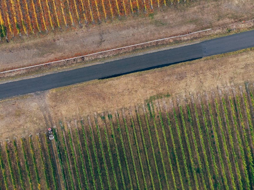
Route 3: Yeongdong Wine Country Roads (영동 포도밭 드라이브) — Korea’s Unexpected Wine Belt
Chungcheongbuk-do’s Yeongdong County produces over 40% of Korea’s domestic wine grapes, yet almost no one drives through its vineyard roads as a destination in themselves. The grid of local roads between National Route 4 and Local Route 901 cuts through rolling hills that, in late September to early October, turn into an amber-purple patchwork that rivals any Burgundy postcard.
In 2026, the Yeongdong Wine Tunnel (영동 와인터널) has expanded its tasting menu and now operates until 8 PM on weekends — making a sunset vineyard drive followed by a tunnel tasting session a genuinely complete itinerary. The road surface on Local Route 901 north of Simcheon village was repaved in late 2025, so the driving experience is now smooth where it used to be rough.
Research Corner: What Korean Road Trip Communities Are Saying in 2026
The Korean online community for road trips, Bobaedream (보배드림) and the dedicated forum 드라이브인코리아, have seen a notable shift in conversation since 2024. Members increasingly post GPS track files (GPX format) of discovered routes rather than just location names — a habit borrowed from the international cycling and overlanding community.
Cross-referencing with Google Maps Street View data (still one of the most underused research tools for Korean road trips) and Kakao Map’s “road surface condition” layer, several patterns emerge among the most-discussed secret routes:
- Best time windows: Tuesday–Thursday mornings see 60–70% less traffic even on “discovered” scenic roads
- Average route length: The most beloved hidden drives average 90–140 km — long enough to feel like an adventure, short enough for a single day
- Fuel planning: Independent GS Caltex or S-Oil stations in rural areas close by 7–8 PM; always check Kakao Map’s gas station hours before entering remote sections
- Road surface rating: Local routes (지방도) with numbers above 800 tend to be the most scenic but also least maintained — check recent road condition reports on the National Route Information Center (도로정보서비스, www.its.go.kr)
- Navigation hack: Switch your Kakao or Tmap routing to “일반도로 우선” (prioritize general roads) mode to avoid being funneled onto expressways
The One Route I’m Not Publishing in Full — And Why
There’s a coastal road in northern Gyeongbuk that I drove twice this past winter. It runs parallel to a decommissioned military fence line and opens up to a completely unspoiled pine forest coastline. I’m deliberately keeping the exact GPS coordinates offline for now — not to be precious about it, but because two of the most-loved “secret spots” in Korea (Jeju’s Seopjikoji and Yangyang’s Surfyy Beach area) went from 200 visitors a weekend to 2,000 within 18 months of going viral. The road infrastructure simply couldn’t handle it, and the natural quality that made them special degraded fast.
The lesson isn’t gatekeeping — it’s pacing. Share secret routes with the 3–5 people you trust to treat them well. The route will still be there for everyone eventually, just without the damage that comes from overnight virality.
Practical Prep: What Your Car Actually Needs for These Routes
Most of these roads are fully paved, so you don’t need an SUV or 4WD. That said:
- Ground clearance matters on coastal gravel sections: anything over 150mm is fine; stock sedan sedans usually clear these sections
- Tire condition check: Hairpin mountain roads put real lateral stress on tires — inspect sidewall condition before heading to Jeongseon-type routes
- Dashcam with GPS logging: Invaluable for retracing routes later and sharing accurate GPX files with friends
- Offline maps: Download MAPS.ME or Kakao Offline sections — cell coverage drops on several mountain routes
- Emergency triangle + reflective vest: Required by Korean law anyway, but doubly important on narrow mountain roads
Alternatives If You Can’t Do Long Routes
Not everyone can block out a full day. If you’re working with 3–4 hours, consider micro-drives: the Han River north bank roads (북한강 강변도로) between Yangpyeong and Chuncheon offer consistently beautiful stretches that you can enter and exit flexibly without committing to a full loop. Similarly, the Nakdong River bike/drive road sections near Andong (안동) have been extended and improved in 2026 specifically for casual leisure driving — Google Maps now tags them as “scenic roads” which makes them easy to find even for first-timers.
The point isn’t to find THE secret road. It’s to develop the habit of looking one layer deeper than where everyone else is looking.
Editor’s Comment : After logging more than 15,000 km on Korean back roads over the past few years, the single most reliable method I’ve found for discovering secret routes is embarrassingly low-tech: ask the owner of a small rural restaurant where the “pretty road” nearby is. Not “scenic spot” (관광지), but “pretty road” (예쁜 길). They almost always know one that isn’t on any map app, and they’re often delighted that someone actually wants to hear about it. That conversation has led me to more remarkable drives than any algorithm ever has.
📚 관련된 다른 글도 읽어 보세요
- 아이들이 먼저 가자고 조르는 국내 가족 캠핑 명소 TOP 7: 2026 실패 없는 코스 총정리
- 3-Generation Family Travel in 2026: The Ultimate Guide to Planning Trips with Grandparents (Without the Stress)
- 지도 앱 꺼버리고 떠난 사람들이 찾은 로컬 탐방 국내 여행 블로그 추천 TOP 7 [2026 실검 분석]
태그: Korea hidden drive routes, 국내 비밀 드라이브 코스, Korean scenic roads 2026, Korean road trip guide, secret travel spots Korea, Goheung drive, Jeongseon loop road
Leave a Reply